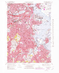
1970 Map of Boston South
USGS Topo · Published 1979About this map
The Charles River Basin and the dense urban core of Boston anchor this 1970s record, capturing a period of significant transit and infrastructure revision. Purple revision overlays highlight the expansion of modern highways and changes to the city's complex shoreline, from the industrial Reserved Channel in South Boston to the burgeoning runways of Logan International Airport. The map traces a high concentration of institutional and historical landmarks, including the prestigious campuses of Harvard University and the Mass Institute of Technology, as well as the venerable Faneuil Hall in the city center.
Find a feature on this map
159 named features on this map. Tap any name to fly to it.
Don’t see what you’re looking for? This feature index may not catch every label — zoom into the map to look around manually.
Map Details
Editions of this 1970 Boston South Map
2 editions found
Other maps of this area

1885 · Abington
USGS Topo · 1:62,500

1886 · Dedham
USGS Topo · 1:62,500

1888 · Abington
USGS Topo · 1:62,500

1892 · Boston Bay
USGS Topo · 1:62,500

1893 · Abington
USGS Topo · 1:62,500

1893 · Boston
USGS Topo · 1:62,500

1894 · Dedham
USGS Topo · 1:62,500

1903 · Boston
USGS Topo · 1:62,500

1903 · Boston Bay
USGS Topo · 1:62,500

1919 · Dedham
USGS Topo · 1:62,500