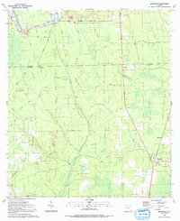
1991 Map of Bostwick
USGS Topo · Published 1991About this map
Bostwick and Sun Garden serve as the primary residential anchors in this 1991 survey of the borderlands between Clay and Putnam Counties. The landscape is a mosaic of low-lying wetlands and industrial activity, notably defined by the presence of a Strip Mine and associated Tailings in the northern reach near Clarkes Creek. The area's history is inscribed in its transit network, which includes the Old RR Gr and a dense web of local routes like Warner Road and Georges Lake Road. A Lookout Tower near the county line and the DeCoy Ch represent established community landmarks amidst the drainage systems of Simms Creek and Harvey Creek. The terrain's character is further shaped by an extensive Levee system and numerous sandpits, illustrating a region defined by its natural hydrology and resource extraction.
Find a feature on this map
35 named features on this map. Tap any name to fly to it.
Don’t see what you’re looking for? This feature index may not catch every label — zoom into the map to look around manually.
Map Details
Editions of this 1991 Bostwick Map
This is the sole edition of this map. No revisions or reprints were ever made.
Other maps of this area

1912 · Palatka
USGS Topo · 1:48,000

1915 · Palatka
USGS Topo · 1:62,500

1915 · Interlachen
USGS Topo · 1:48,000

1916 · Interlachen
USGS Topo · 1:62,500

1942 · Ates Creek
USGS Topo · 1:62,500

1944 · Interlachen
USGS Topo · 1:62,500

1947 · Bostwick
USGS Topo · 1:50,000

1949 · Rice Creek
USGS Topo · 1:24,000

1949 · Bostwick
USGS Topo · 1:24,000

1949 · Green Cove Springs
USGS Topo · 1:24,000