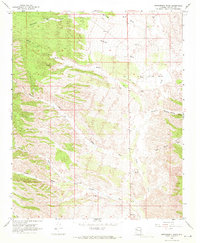
1968 Map of Bottleneck Wash
USGS Topo · Published 1971About this map
Bottleneck Wash and its complex network of seasonal drainages define this arid pocket of Mohave County during the late 1960s. The landscape is marked by the infrastructure of cattle ranching and early prospecting, with scattered water sources like Government Tank and Antelope Well serving as vital hubs for remote operations. Isolated outposts such as Round Valley Ranch and Windmill Ranch appear along the drainage systems of Round Valley Creek and Knight Creek, highlighting the sparse but deliberate settlement patterns of the era. The presence of the Kabba Mine and a Borrow Pit near McGarrys Wash points to the area's mineral and material extraction efforts. A series of Jeep Trails wind through the varied topography of Wheeler and Antelope, connecting these remote ranching sites and wells across a terrain segmented by fences and benchmarks.
Find a feature on this map
37 named features on this map. Tap any name to fly to it.
Don’t see what you’re looking for? This feature index may not catch every label — zoom into the map to look around manually.
Map Details
Editions of this 1968 Bottleneck Wash Map
2 editions found
Other maps of this area

1886 · Diamond Creek
USGS Topo · 1:250,000

1892 · Diamond Creek
USGS Topo · 1:250,000

1923 · Signal
USGS Topo · 1:250,000

1942 · Signal
USGS Topo · 1:250,000

1948 · Williams
USGS Topo · 1:250,000

1950 · Prescott
USGS Topo · 1:250,000

1954 · Prescott
USGS Topo · 1:250,000

1954 · Williams
USGS Topo · 1:250,000

1956 · Williams
USGS Topo · 1:250,000

1958 · Prescott
USGS Topo · 1:250,000