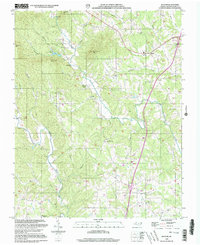
2000 Map of Bottom
USGS Topo · Published 2003About this map
The Fisher River and Mitchell River drain this portion of the Piedmont, where agricultural valleys are bounded by the rising slopes of Skull Camp Mtn and Raven Knob. This survey reflects a landscape defined by small rural hubs and historical religious centers at the turn of the 21st century. Highlighting the local community structure are the Beulah Sch and several country churches, including New Bethel Ch and Salem Fork Ch. The presence of Camp Raven Knob in the western hills and the rural commercial node at Blevins Store provide a window into the region's mid-to-late 20th-century development. While modern transport is evidenced by Interchange 100, the map preserves the names of smaller, older settlements like Ladonia and Bottom, offering genealogists a clear view of how these communities related to the local terrain.
Find a feature on this map
39 named features on this map. Tap any name to fly to it.
Don’t see what you’re looking for? This feature index may not catch every label — zoom into the map to look around manually.
Map Details
Editions of this 2000 Bottom Map
This is the sole edition of this map. No revisions or reprints were ever made.
Other maps of this area

1889 · Hillsville
USGS Topo · 1:125,000

1891 · Yadkinville
USGS Topo · 1:125,000

1892 · Hillsville
USGS Topo · 1:125,000

1893 · Yadkinville
USGS Topo · 1:125,000

1896 · Hillsville
USGS Topo · 1:125,000

1931 · Galax
USGS Topo · 1:48,000

1933 · Galax
USGS Topo · 1:62,500

1953 · Winston-Salem
USGS Topo · 1:250,000

1955 · Winston-Salem
USGS Topo · 1:250,000

1957 · Mount Airy
USGS Topo · 1:62,500