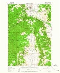
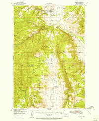
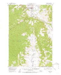
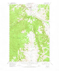
1954 Map of Boulder
USGS Topo · Published 1964About this map
The town of Boulder serves as the central hub of this Jefferson County landscape, situated along the Boulder River and the Great Northern railway. This mid-century survey illustrates a region defined by its extraction history and thermal waters, notably the Boulder Hot Springs and the scattered Chinese Diggings which point to earlier mining eras. The Montana State Training School occupies a significant tract just south of the town center, while the Boulder Cem provides a valuable anchor for genealogical research. Higher elevations within the Deerlodge National Forest and the Bull Mountain range are marked by active and historical mining sites such as the Mountain Queen Mine and May Day Mine. The presence of numerous family-named properties like Keogh Ranch, McCauley Ranch, and Murphy Ranch indicates a stable ranching economy established along the drainage basins of Whitetail Basin and Muskrat Creek.
Find a feature on this map
83 named features on this map. Tap any name to fly to it.
Don’t see what you’re looking for? This feature index may not catch every label — zoom into the map to look around manually.
Map Details
Editions of this 1954 Boulder Map
4 editions found
Other maps of this area

1886 · Fort Logan
USGS Topo · 1:250,000

1888 · Three Forks
USGS Topo · 1:250,000

1889 · Helena
USGS Topo · 1:250,000

1893 · Helena
USGS Topo · 1:250,000

1893 · Dillon
USGS Topo · 1:250,000

1894 · Three Forks
USGS Topo · 1:250,000

1895 · Three Forks
USGS Topo · 1:250,000

1899 · Boulder
USGS Topo · 1:125,000

1899 · Helena
USGS Topo · 1:250,000

1903 · Helena
USGS Topo · 1:250,000
Featured Places
- Boulder, MT
- Sunset Trailer Court, Boulder
- Mountain Valley Trailer Court, Boulder
- Jefferson County, MT
- United States