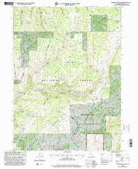
1998 Map of Boulder Mountain
USGS Topo · Published 2001About this map
Hardware Ranch anchors the southeastern reaches of this terrain, situated within a broader conservation landscape designated as the Hardware Ranch Wildlife Management Area. The geography is defined by the deep incisions of the Blacksmith Fork and its Left Hand Fork, which drain the surrounding highlands of the Cache National Forest. In the central portion of the map, Boulder Mountain rises above a complex system of drainage hollows, including Steel Hollow and Herd Hollow.
Find a feature on this map
65 named features on this map. Tap any name to fly to it.
Don’t see what you’re looking for? This feature index may not catch every label — zoom into the map to look around manually.
Map Details
Editions of this 1998 Boulder Mountain Map
This is the sole edition of this map. No revisions or reprints were ever made.
Other maps of this area

1912 · Randolph
USGS Topo · 1:125,000

1914 · Logan
USGS Topo · 1:125,000

1916 · Logan
USGS Topo · 1:125,000

1949 · Boulter Mts
USGS Topo · 1:24,000

1954 · Ogden
USGS Topo · 1:250,000

1958 · Ogden
USGS Topo · 1:250,000

1960 · Ogden
USGS Topo · 1:250,000

1969 · Boulder Mtn
USGS Topo · 1:24,000
1969 · Porcupine Reservoir
USGS Topo · 1:24,000
1969 · Hardware Ranch
USGS Topo · 1:24,000