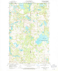
1968 Map of Boundary Lake
USGS Topo · Published 1971About this map
The Turtle Mountains dominate this landscape along the international border, where the Canada-United States boundary bisects Boundary Lake. This 1960s terrain study reveals a high-density lake region, with many water bodies bearing family or local names such as Lagerquist Lake, Bergen Lake, and Walker Lake. The area reflects a commitment to conservation at the time, featuring the Rabb Lake National Wildlife Refuge and Willow National Wildlife Refuge.
Find a feature on this map
32 named features on this map. Tap any name to fly to it.
Don’t see what you’re looking for? This feature index may not catch every label — zoom into the map to look around manually.
Map Details
Editions of this 1968 Boundary Lake Map
This is the sole edition of this map. No revisions or reprints were ever made.
Other maps of this area

1935 · Dunseith
USGS Topo · 1:48,000

1939 · Dunseith
USGS Topo · 1:62,500

1954 · Minot
USGS Topo · 1:250,000

1955 · Lords Lake
USGS Topo · 1:24,000

1955 · Dunseith
USGS Topo · 1:24,000

1955 · Bottineau SE
USGS Topo · 1:24,000

1956 · Metigoshe Lake
USGS Topo · 1:24,000
1956 · Lords Lake
USGS Topo · 1:25,000

1958 · Minot
USGS Topo · 1:250,000
1968 · International Peace Garden
USGS Topo · 1:24,000