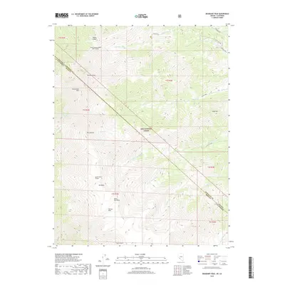
2018 Map of Boundary Peak
USGS Topo · Published 2018About this map
Boundary Peak stands as the highest point in Nevada on this high-altitude borderland between Nevada and California. The terrain transitions from the steep escarpments of the White-Inyo Range to the vast high-elevation plateau of Pellisier Flats. Within the Inyo National Forest, the landscape is defined by deep drainages like Queen Dicks Canyon and Trail Canyon, which carry seasonal water from the peaks toward the arid basins below. Industrial history is etched into the northern slopes near the Nevada-California state line, where the B&B Mine Road and Red Rock Mine indicate the region's legacy of high-desert mineral extraction. The map also captures the stark prominence of Montgomery Peak and Mt Dubois, illustrating a complex topography where ridges like The Jumpoff drop sharply into the creek beds of N Fork Chiatovich Cr.
Find a feature on this map
34 named features on this map. Tap any name to fly to it.
Don’t see what you’re looking for? This feature index may not catch every label — zoom into the map to look around manually.
Map Details
Editions of this 2018 Boundary Peak Map
This is the sole edition of this map. No revisions or reprints were ever made.
Other maps of this area

1917 · White Mountain
USGS Topo · 1:125,000

1947 · Mariposa
USGS Topo · 1:250,000

1948 · Mariposa
USGS Topo · 1:250,000

1957 · Mariposa
USGS Topo · 1:250,000

1962 · Benton
USGS Topo · 1:62,500

1962 · Mt. Barcroft
USGS Topo · 1:62,500

1962 · White Mtn. Peak
USGS Topo · 1:62,500

1963 · Mariposa
USGS Topo · 1:250,000

1963 · Davis Mountain
USGS Topo · 1:62,500
1987 · Volcanic Hills West
USGS Topo · 1:24,000