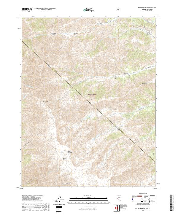
2021 Map of Boundary Peak
USGS Topo · Published 2021About this map
Boundary Peak and Montgomery Peak dominate the skyline along the high-altitude crest of the White Mountains. This map documents the state line dividing Esmeralda County, Nevada, and Mono County, California, cutting through a landscape of extreme vertical relief. High-country plateaus like Pellisier Flats sit adjacent to steep drainage headwaters such as Trail Canyon and Falls Canyon. Historical mining interests are evident on the Nevada side through the presence of B&B Mine Road and the Red Rock Mine near Dry Creek. The survey clearly delineates the boundaries of the Inyo National Forest, providing a detailed view of the paths and landmarks used by surveyors and explorers, from the saddle of Trail Canyon Saddle to the sheer drops at The Jumpoff.
Find a feature on this map
34 named features on this map. Tap any name to fly to it.
Don’t see what you’re looking for? This feature index may not catch every label — zoom into the map to look around manually.
Map Details
Editions of this 2021 Boundary Peak Map
This is the sole edition of this map. No revisions or reprints were ever made.
Other maps of this area

1917 · White Mountain
USGS Topo · 1:125,000

1947 · Mariposa
USGS Topo · 1:250,000

1948 · Mariposa
USGS Topo · 1:250,000

1957 · Mariposa
USGS Topo · 1:250,000

1962 · Benton
USGS Topo · 1:62,500

1962 · Mt. Barcroft
USGS Topo · 1:62,500

1962 · White Mtn. Peak
USGS Topo · 1:62,500

1963 · Mariposa
USGS Topo · 1:250,000

1963 · Davis Mountain
USGS Topo · 1:62,500
1987 · Volcanic Hills West
USGS Topo · 1:24,000