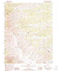
1987 Map of Boundary Peak
USGS Topo · Published 1987About this map
Boundary Peak 13140, the highest point in Nevada, dominates this high-altitude landscape along the border of Esmeralda and Mono Counties. The terrain represents a significant crest of the White Mountains, where the state line between Nevada and California bisects massive summits like Montgomery Peak 13441 and reaches toward Mount Dubois 13559. This is a landscape of extreme verticality, featuring the sheer drop of The Jumpoff and the sprawling high-elevation expanse of Pellisier Flats. Within the Inyo National Forest, the map traces the drainages of Chiatovich Creek and Morris Creek, highlighting a remote wilderness environment. Scattered evidence of human activity is minimal, appearing as a lone Prospect in the northeast and a primitive Trail through Trail Canyon Saddle, reflecting the isolation of this portion of the Great Basin.
Find a feature on this map
27 named features on this map. Tap any name to fly to it.
Don’t see what you’re looking for? This feature index may not catch every label — zoom into the map to look around manually.
Map Details
Editions of this 1987 Boundary Peak Map
This is the sole edition of this map. No revisions or reprints were ever made.
Other maps of this area

1917 · White Mountain
USGS Topo · 1:125,000

1947 · Mariposa
USGS Topo · 1:250,000

1948 · Mariposa
USGS Topo · 1:250,000

1957 · Mariposa
USGS Topo · 1:250,000

1962 · Benton
USGS Topo · 1:62,500

1962 · Mt. Barcroft
USGS Topo · 1:62,500

1962 · White Mtn. Peak
USGS Topo · 1:62,500

1963 · Mariposa
USGS Topo · 1:250,000

1963 · Davis Mountain
USGS Topo · 1:62,500
1987 · Volcanic Hills West
USGS Topo · 1:24,000