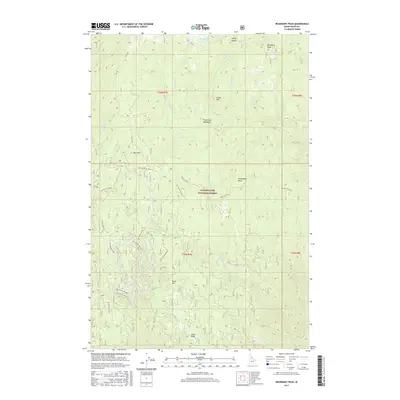
2017 Map of Boundary Peak
USGS Topo · Published 2017About this map
Clearwater National Forest dominates this landscape in northern Idaho, defined by high peaks and an intricate network of forest service roads. The historic Lolo Trl crosses the northern terrain, following the ridgelines near Eldorado Cr and Hungery Cr, a route central to the region’s early transit history. The map detail highlights the complex drainage system of the Clearwater basin, including Fish Creek Meadows and numerous tributaries like Mex Cr and Deadman Cr. High points such as Boundary Peak, Mex Mtn, and Frenchman Butte offer distinct geographic landmarks. The transition from these summits to the valley floors is marked by features like Windy Saddle and Cedar Knob, illustrating the difficult topography that dictated the placement of early routes such as the Dead Man Rd.
Find a feature on this map
48 named features on this map. Tap any name to fly to it.
Don’t see what you’re looking for? This feature index may not catch every label — zoom into the map to look around manually.
Map Details
Editions of this 2017 Boundary Peak Map
This is the sole edition of this map. No revisions or reprints were ever made.
Other maps of this area

1911 · Lolo
USGS Topo · 1:250,000

1913 · Lolo
USGS Topo · 1:250,000

1924 · Weippe
USGS Topo · 1:125,000

1956 · Hamilton
USGS Topo · 1:250,000

1959 · Hamilton
USGS Topo · 1:250,000

1960 · Hamilton
USGS Topo · 1:250,000

1964 · Hamilton
USGS Topo · 1:250,000
1966 · Hemlock Butte
USGS Topo · 1:24,000

1966 · Lowell
USGS Topo · 1:24,000
1966 · Snowy Summit
USGS Topo · 1:24,000