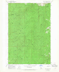
1966 Map of Snowy Summit
USGS Topo · Published 1968About this map
Clearwater National Forest dominates this mid-1960s survey, straddling the boundary between Clearwater and Idaho Counties. The landscape is defined by its network of administrative and seasonal outposts, including Snowy Summit, Soldier Meadows, and Camp Martin. These locations, along with Nineteenmile Camp and Savage Camp, reflect the region's history as a managed wilderness area where forest service activity and pack animal transport were primary.
Find a feature on this map
34 named features on this map. Tap any name to fly to it.
Don’t see what you’re looking for? This feature index may not catch every label — zoom into the map to look around manually.
Map Details
Editions of this 1966 Snowy Summit Map
2 editions found
Other maps of this area

1911 · Lolo
USGS Topo · 1:250,000

1913 · Lolo
USGS Topo · 1:250,000

1923 · Washington Creek
USGS Topo · 1:125,000

1924 · Weippe
USGS Topo · 1:125,000

1956 · Hamilton
USGS Topo · 1:250,000

1959 · Hamilton
USGS Topo · 1:250,000

1960 · Hamilton
USGS Topo · 1:250,000

1964 · Hamilton
USGS Topo · 1:250,000

1965 · Lean-to Point
USGS Topo · 1:24,000
1965 · Larch Butte
USGS Topo · 1:24,000