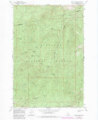
1966 Map of Snowy Summit
USGS Topo · Published 1984About this map
Clearwater National Forest dominates this mountain landscape along the border of Clearwater and Idaho Counties. This 1960s terrain, photorevised in the early 1980s, is defined by an extensive network of pack trails and jeep trails that navigate the high ridges and steep drainages. High points like Snowy Summit and Hemlock Ridge overlook a primitive backcountry where seasonal camps and junctions form the primary human footprint. Locations such as Savage Camp, Camp Martin Campground, and the uniquely named Jerusalem Artichokes Campsite indicate a history of forestry management and wilderness recreation.
Find a feature on this map
37 named features on this map. Tap any name to fly to it.
Don’t see what you’re looking for? This feature index may not catch every label — zoom into the map to look around manually.
Map Details
Editions of this 1966 Snowy Summit Map
2 editions found
Other maps of this area

1911 · Lolo
USGS Topo · 1:250,000

1913 · Lolo
USGS Topo · 1:250,000

1923 · Washington Creek
USGS Topo · 1:125,000

1924 · Weippe
USGS Topo · 1:125,000

1956 · Hamilton
USGS Topo · 1:250,000

1959 · Hamilton
USGS Topo · 1:250,000

1960 · Hamilton
USGS Topo · 1:250,000

1964 · Hamilton
USGS Topo · 1:250,000

1965 · Lean-to Point
USGS Topo · 1:24,000
1965 · Larch Butte
USGS Topo · 1:24,000