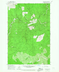
1965 Map of Larch Butte
USGS Topo · Published 1967About this map
Clearwater National Forest defines the landscape of this 1965 survey, showcasing a rugged stretch of the Idaho backcountry during the mid-century era. The terrain is characterized by prominent elevations such as Larch Butte and Gobblers Knob, which served as critical landmarks for navigation and forest management. A primitive network of transportation is evident, featuring a primary Pack Trail that traverses the high ground of Tamarack Ridge and Hemlock Ridge. The map documents a watershed defined by numerous drainages including Orogrande Creek, Tama Creek, and French Creek. The presence of Three Bear Camp suggests a history of seasonal usage by foresters or hunters, while places like Sylvan Saddle and Sevenmile Point indicate established local naming conventions for key mountain passes and lookouts used before more modern infrastructure arrived in this part of Idaho.
Find a feature on this map
27 named features on this map. Tap any name to fly to it.
Don’t see what you’re looking for? This feature index may not catch every label — zoom into the map to look around manually.
Map Details
Editions of this 1965 Larch Butte Map
2 editions found
Other maps of this area

1911 · Lolo
USGS Topo · 1:250,000

1913 · Lolo
USGS Topo · 1:250,000

1923 · Washington Creek
USGS Topo · 1:125,000

1924 · Weippe
USGS Topo · 1:125,000

1956 · Hamilton
USGS Topo · 1:250,000

1959 · Hamilton
USGS Topo · 1:250,000

1960 · Hamilton
USGS Topo · 1:250,000

1963 · Clarke Mtn
USGS Topo · 1:24,000

1964 · Hamilton
USGS Topo · 1:250,000

1965 · Lean-to Point
USGS Topo · 1:24,000