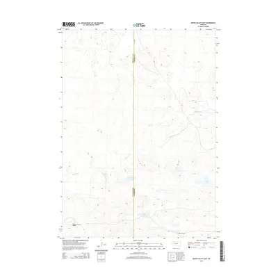
2014 Map of Bovee Valley East
USGS Topo · Published 2014About this map
Snake River winds across this portion of the Nebraska Sandhills, carving a distinct path through the rolling dune topography of Cherry and Sheridan counties. The landscape is defined by a series of isolated basins and alkaline lakes, including Hackberry Lake, Chokecherry Lake, and the larger Big Lake to the east. These water bodies, along with Hart Lake and Cedar Lake, represent the unique hydrology of the Bovee Valley region, where the high water table of the Ogallala Aquifer intersects the surface. Settlement is sparse, represented primarily by a thin network of local routes like Fawn Lake Rd and 130th Ln. The map illustrates the 21st-century state of this cattle-ranching country, where the boundary between Sheridan and Cherry counties cuts straight through the open range, and remote access is maintained via improved tracks like 448th Trl.
Find a feature on this map
11 named features on this map. Tap any name to fly to it.
Don’t see what you’re looking for? This feature index may not catch every label — zoom into the map to look around manually.
Map Details
Editions of this 2014 Bovee Valley East Map
This is the sole edition of this map. No revisions or reprints were ever made.
Other maps of this area
1948 · Spade Ranch
USGS Topo · 1:62,500
1949 · Turpin Lake
USGS Topo · 1:62,500
1950 · Spade Ranch
USGS Topo · 1:62,500
1951 · Gypsy Valley
USGS Topo · 1:62,500
1951 · Turpin Lake
USGS Topo · 1:62,500

1955 · Alliance
USGS Topo · 1:250,000

1957 · Alliance
USGS Topo · 1:250,000

1957 · Valentine
USGS Topo · 1:250,000

1958 · Alliance
USGS Topo · 1:250,000

1959 · Valentine
USGS Topo · 1:250,000