
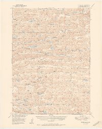
1951 Map of Turpin Lake
USGS Topo · Published 1951About this map
The vast ranching landscape of Cherry County, Nebraska, is revealed through its extensive network of family holdings and localized valley systems. Prominent family names are etched into the terrain at the Skanadore Ranch, Gorley Ranch, and the Winston Ranch, illustrating the dispersed pattern of mid-century Sandhills life. This land is punctuated by an incredible density of small lakes and valley formations like Gordon Valley, Waupan Valley, and the aptly named Ideal Valley.
Find a feature on this map
77 named features on this map. Tap any name to fly to it.
Don’t see what you’re looking for? This feature index may not catch every label — zoom into the map to look around manually.
Map Details
Editions of this 1951 Turpin Lake Map
2 editions found
Other maps of this area

1948 · Ashby
USGS Topo · 1:62,500

1948 · Bingham
USGS Topo · 1:62,500

1948 · Spade Ranch
USGS Topo · 1:62,500

1948 · Whitman
USGS Topo · 1:62,500

1949 · Ashby
USGS Topo · 1:62,500

1949 · Steverson Lake
USGS Topo · 1:62,500

1949 · Turpin Lake
USGS Topo · 1:62,500

1950 · Whitman
USGS Topo · 1:62,500

1950 · Spade Ranch
USGS Topo · 1:62,500

1950 · Bingham
USGS Topo · 1:62,500