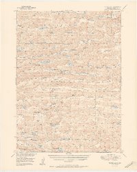
1951 Map of Turpin Lake
USGS Topo · Published 1951About this map
The Tennessee Valley and the surrounding Sandhills of Cherry County are defined by a network of ranching operations and isolated prairie schools in the mid-20th century. Numerous family-named holdings like the Beckwith Ranch, Skanadore Ranch, and Jackson Ranch are scattered across a landscape dominated by depressions and numerous small water bodies such as Rat Lake, Dry Lake, and Niggerhead Lake. This 1951 edition reflects a time when the rural education system was still robustly represented by numbered outposts including School No 162 and School No 114. The hydrology of the region is notably diverse, with drainage features like Gordon Creek and unique landmarks such as Dead Cow Lake and Rattlesnake Lake providing essential water sources for the cattle-driven economy. The map also traces the distinct corridors of the Waupan Valley and Ideal Valley, where many ranch headquarters are situated.
Find a feature on this map
73 named features on this map. Tap any name to fly to it.
Don’t see what you’re looking for? This feature index may not catch every label — zoom into the map to look around manually.
Map Details
Editions of this 1951 Turpin Lake Map
2 editions found

Other maps of this area

1948 · Ashby
USGS Topo · 1:62,500

1948 · Bingham
USGS Topo · 1:62,500

1948 · Spade Ranch
USGS Topo · 1:62,500

1948 · Whitman
USGS Topo · 1:62,500

1949 · Ashby
USGS Topo · 1:62,500

1949 · Steverson Lake
USGS Topo · 1:62,500

1949 · Turpin Lake
USGS Topo · 1:62,500

1950 · Whitman
USGS Topo · 1:62,500

1950 · Spade Ranch
USGS Topo · 1:62,500

1950 · Bingham
USGS Topo · 1:62,500