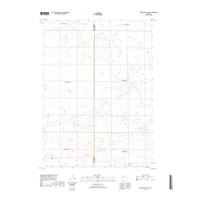
2017 Map of Bovee Valley East
USGS Topo · Published 2017About this map
Bovee Valley defines the southern reach of this Nebraska landscape, where the Snake River cuts through the Nebraska Sandhills. The area is characterized by numerous isolated water bodies including Big Lake, Hart Lake, and Cedar Lake, illustrating the distinctive hydrology of the region. This 2017 survey shows a land shaped by its county boundaries, specifically the divide between Sheridan Co and Cherry Co. Transportation through this remote terrain relies on local routes like Fawn Lake Rd and numbered trails such as 456 Trl. Smaller features like Hackberry Lake and Chokecherry Lake provide important landmarks for local navigation and land use within the township and range system.
Find a feature on this map
18 named features on this map. Tap any name to fly to it.
Don’t see what you’re looking for? This feature index may not catch every label — zoom into the map to look around manually.
Map Details
Editions of this 2017 Bovee Valley East Map
This is the sole edition of this map. No revisions or reprints were ever made.
Other maps of this area
1948 · Spade Ranch
USGS Topo · 1:62,500
1949 · Turpin Lake
USGS Topo · 1:62,500
1950 · Spade Ranch
USGS Topo · 1:62,500
1951 · Gypsy Valley
USGS Topo · 1:62,500
1951 · Turpin Lake
USGS Topo · 1:62,500

1955 · Alliance
USGS Topo · 1:250,000

1957 · Alliance
USGS Topo · 1:250,000

1957 · Valentine
USGS Topo · 1:250,000

1958 · Alliance
USGS Topo · 1:250,000

1959 · Valentine
USGS Topo · 1:250,000