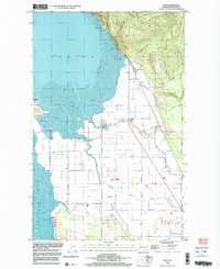
1998 Map of Bow
USGS Topo · Published 2003About this map
Chuckanut Mountain overlooks the transition from coastal wetlands to the agricultural flats of the Skagit Valley on this 1990s survey. The landscape is defined by an intricate network of water management, where the Samish River and Joe Leary Slough wind through lowlands protected by extensive levee systems. Small settlements like Edison and Bow serve as the focal points for this rural community, situated near the intersection of historic rail lines and tidal flats.
Find a feature on this map
41 named features on this map. Tap any name to fly to it.
Don’t see what you’re looking for? This feature index may not catch every label — zoom into the map to look around manually.
Map Details
Editions of this 1998 Bow Map
This is the sole edition of this map. No revisions or reprints were ever made.
Other maps of this area

1911 · Mount Vernon
USGS Topo · 1:125,000

1918 · Samish Lake
USGS Topo · 1:62,500

1940 · Mt Vernon
USGS Topo · 1:62,500

1943 · Mt Vernon
USGS Topo · 1:62,500

1943 · Deception Pass
USGS Topo · 1:62,500

1943 · Anacortes
USGS Topo · 1:62,500

1951 · Deception Pass
USGS Topo · 1:62,500

1951 · Anacortes
USGS Topo · 1:62,500

1952 · Lake Whatcom
USGS Topo · 1:24,000

1952 · Alger
USGS Topo · 1:24,000