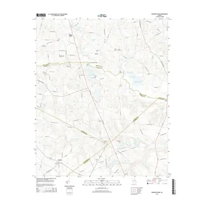
2014 Map of Bowdens Pond
USGS Topo · Published 2014About this map
Happy Valley and the surrounding rural communities of Autney and Hadden define the landscape at the junction of McDuffie, Warren, and Jefferson counties. This area is characterized by a dense network of family and community history, evidenced by numerous small burying grounds including the Barksdale-Story Bradshaw Cem, Jones Grove Cem, and Mt Aldred Cem. The local industry is anchored by the Kaolin Mines Lake, a clear marker of the region’s geological wealth and mining heritage. The terrain is drained by Brier Creek and its many tributaries, while the topography rises toward Little Brasstown Gap. This survey documents a quiet rural pocket where small-scale farming and resource extraction have left a lasting imprint on the land, from the Huff Bridge to the complex of water bodies known as Bowdens Pond Number One and Bowdens Pond Number Two.
Find a feature on this map
138 named features on this map. Tap any name to fly to it.
Don’t see what you’re looking for? This feature index may not catch every label — zoom into the map to look around manually.
Map Details
Editions of this 2014 Bowdens Pond Map
This is the sole edition of this map. No revisions or reprints were ever made.
Other maps of this area

1920 · Stapleton
USGS Topo · 1:62,500

1922 · Harlem
USGS Topo · 1:62,500

1948 · Harlem
USGS Topo · 1:62,500

1948 · Stapleton
USGS Topo · 1:62,500

1948 · Harlem
USGS Topo · 1:24,000

1948 · Thomson East
USGS Topo · 1:24,000

1950 · Dearing
USGS Topo · 1:24,000

1950 · Wrens
USGS Topo · 1:24,000
1950 · Harlem
USGS Topo · 1:24,000

1950 · Matthews
USGS Topo · 1:24,000