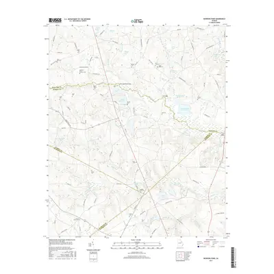
2017 Map of Bowdens Pond
USGS Topo · Published 2017About this map
Kaolin Mines Lake sits at the center of this Georgia landscape where the borders of McDuffie, Warren, Glasscock, and Jefferson counties converge. The geography is defined by a dense concentration of family cemeteries, including the multi-surname Barksdale-Story-Bradshaw Cem and Jones Grove Cem, suggesting a long history of generational land ownership. Waterways like Brier Creek and Reedy Cr wind through the terrain, feeding numerous named bodies of water such as Bowdens Pond Number One and Johnson Pond. The presence of Huff Bridge and Luckie Bridge over the creeks, alongside features like Little Brasstown Gap, highlights the natural crossings and elevation changes that shaped the local road network. This survey documents the rural character of the region, where legacy homesteads and small-scale hydraulic features remain primary landmarks.
Find a feature on this map
100 named features on this map. Tap any name to fly to it.
Don’t see what you’re looking for? This feature index may not catch every label — zoom into the map to look around manually.
Map Details
Editions of this 2017 Bowdens Pond Map
This is the sole edition of this map. No revisions or reprints were ever made.
Other maps of this area

1920 · Stapleton
USGS Topo · 1:62,500

1922 · Harlem
USGS Topo · 1:62,500

1948 · Harlem
USGS Topo · 1:62,500

1948 · Stapleton
USGS Topo · 1:62,500

1948 · Harlem
USGS Topo · 1:24,000

1948 · Thomson East
USGS Topo · 1:24,000

1950 · Dearing
USGS Topo · 1:24,000

1950 · Wrens
USGS Topo · 1:24,000
1950 · Harlem
USGS Topo · 1:24,000

1950 · Matthews
USGS Topo · 1:24,000