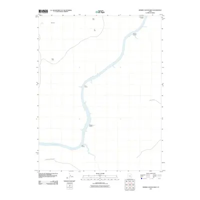
2011 Map of Bowdie Canyon West
USGS Topo · Published 2011About this map
Lake Powell dominates the central corridor of this San Juan County landscape, its waters filling the deep incisions of the Colorado River's drainage system. The map documents the intricate boundary of Glen Canyon National Park, where the rising reservoir meets a series of dramatic geographic features. Significant side drainages like Dark Canyon, Cove Canyon, and Bowdie Canyon show how the landscape was altered by the reservoir's reach into the high desert plateau. Beyond the water's edge, the terrain is defined by sharp verticality at Tar Cliff and Red Point. Human access is sparse, marked primarily by the winding track of Sweet Alice Rd in the southeast, while natural water sources such as Cove Spring persist in the north. This survey illustrates the contrast between the engineered expanse of the lake and the ancient sandstone architecture of Rockfall Canyon and Clearwater Canyon.
Find a feature on this map
13 named features on this map. Tap any name to fly to it.
Don’t see what you’re looking for? This feature index may not catch every label — zoom into the map to look around manually.
Map Details
Editions of this 2011 Bowdie Canyon West Map
This is the sole edition of this map. No revisions or reprints were ever made.
Other maps of this area

1885 · San Rafael
USGS Topo · 1:250,000

1886 · Henry Mountains
USGS Topo · 1:250,000

1892 · Henry Mountains
USGS Topo · 1:250,000
1952 · Mouth of Dark Canyon
USGS Topo · 1:62,500
1952 · Hite
USGS Topo · 1:62,500
1953 · Orange Cliffs 3 SE
USGS Topo · 1:24,000
1953 · Orange Cliffs 4 SW
USGS Topo · 1:24,000
1953 · Fiddler Butte
USGS Topo · 1:62,500
1953 · Orange Cliffs
USGS Topo · 1:62,500
1954 · White Canyon 1 NE
USGS Topo · 1:24,000