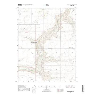
2020 Map of Bowdie Canyon West
USGS Topo · Published 2020About this map
Lake Powell and the Colorado River dominate this desert landscape where the borders of Garfield and San Juan counties meet. The river's path is marked by dramatic elevation changes, including the Dark Canyon Rapids near the mouth of Dark Canyon. This 2020 survey illustrates the high-plateau topography of the Glen Canyon National Recreation Area, featuring prominent landmarks like Dry Mesa and Tar Cliff. Local water sources and catchment features, such as Cove Spring and Freddies Cistern, are vital markers in this arid environment. The sheer verticality of the terrain is evident in the naming of Rockfall Canyon and Fault Point, while the presence of Sweet Alice Rd provides one of the few named access routes through the eastern portion of the quadrangle near Middle Point.
Find a feature on this map
21 named features on this map. Tap any name to fly to it.
Don’t see what you’re looking for? This feature index may not catch every label — zoom into the map to look around manually.
Map Details
Editions of this 2020 Bowdie Canyon West Map
This is the sole edition of this map. No revisions or reprints were ever made.
Other maps of this area

1885 · San Rafael
USGS Topo · 1:250,000

1886 · Henry Mountains
USGS Topo · 1:250,000

1892 · Henry Mountains
USGS Topo · 1:250,000

1952 · Mouth of Dark Canyon
USGS Topo · 1:62,500

1952 · Hite
USGS Topo · 1:62,500

1953 · Orange Cliffs 3 SE
USGS Topo · 1:24,000

1953 · Orange Cliffs 4 SW
USGS Topo · 1:24,000

1953 · Fiddler Butte
USGS Topo · 1:62,500

1953 · Orange Cliffs
USGS Topo · 1:62,500
1954 · White Canyon 1 NE
USGS Topo · 1:24,000