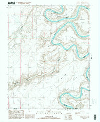
1988 Map of Bowknot Bend
USGS Topo · Published 1988About this map
The Green River carves a massive, looping meander through the high desert plateau in this 1980s provisional survey. The river's path defines the distinct geography of Bowknot Bend, where the water doubles back on itself within Labyrinth Canyon. Along the river banks, a series of flat alluvial benches known as "bottoms" provided rare accessible ground below the sheer cliffs, including Spring Canyon Bottom, Horsethief Bottom, and Saddle Horse Bottom. These areas contrast sharply with the towering landforms of The Spur and Keg Point that dominate the surrounding landscape. The map also records the meeting of four counties—Emery, Grand, Wayne, and San Juan—reflecting how these natural barriers served as administrative boundaries in this remote part of Utah. Traces of human passage are visible in the form of unimproved roads and trails leading to overlooks like Horsethief Point and Deadman Point.
Find a feature on this map
22 named features on this map. Tap any name to fly to it.
Don’t see what you’re looking for? This feature index may not catch every label — zoom into the map to look around manually.
Map Details
Editions of this 1988 Bowknot Bend Map
This is the sole edition of this map. No revisions or reprints were ever made.
Other maps of this area

1885 · San Rafael
USGS Topo · 1:250,000

1885 · La Sal
USGS Topo · 1:250,000

1951 · The Knoll
USGS Topo · 1:62,500

1951 · Upheaval Dome
USGS Topo · 1:62,500

1952 · Tidwell 4 SE
USGS Topo · 1:24,000

1952 · Carlisle 2 NW
USGS Topo · 1:24,000

1952 · Tidwell 4 NE
USGS Topo · 1:24,000

1952 · Moab 3 SW
USGS Topo · 1:24,000

1952 · Moab 3 NW
USGS Topo · 1:24,000

1953 · Orange Cliffs 1 NE
USGS Topo · 1:24,000