1994 Map of Bowling Green
USGS Topo · Published 1997About this map
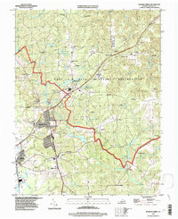
Bowling Green serves as the central hub in this Virginia landscape, where the town's grid meets the expansive Fort A P Hill Military Reservation. The map captures a moment in the mid-1990s where the established civilian settlements of Milford and Wrightsville sit alongside a highly specialized military terrain dotted with an Airstrip No 1, numerous Observation Towers, and a Lookout Tower. The topography is defined by the winding paths of Maracossic Creek and Peumansend Creek, which feed into various water bodies like Elliott Pond and Delos Lake. For local historians and genealogists, the map preserves the locations of community anchors including Antioch Ch, Evergreen Cem, and Green Lawn Cem. The presence of the Rf & P Rr near the western edge illustrates the long-standing importance of rail transport for this portion of Caroline County.
Find a feature on this map
57 named features on this map. Tap any name to fly to it.
Don’t see what you’re looking for? This feature index may not catch every label — zoom into the map to look around manually.
Map Details
Editions of this 1994 Bowling Green Map
This is the sole edition of this map. No revisions or reprints were ever made.
Other maps of this area

1889 · Fredericksburg
USGS Topo · 1:125,000

1892 · Fredericksburg
USGS Topo · 1:125,000

1894 · Fredericksburg
USGS Topo · 1:125,000

1918 · Doswell
USGS Topo · 1:62,500

1918 · Aylett
USGS Topo · 1:62,500

1933 · Aylett
USGS Topo · 1:62,500

1942 · Bowling Green
USGS Topo · 1:31,680

1942 · Upper Zion
USGS Topo · 1:31,680

1942 · Woodford
USGS Topo · 1:31,680

1942 · Guinea
USGS Topo · 1:31,680