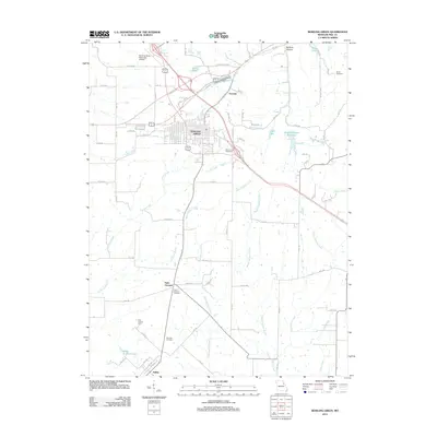
2012 Map of Bowling Green
USGS Topo · Published 2012About this map
Bowling Green serves as the primary hub of this eastern Missouri landscape, where local roads like E Champ Clark Dr and Highway Y radiate from the town center. The settlement pattern extends southward to smaller communities including Saint Clement and Ashley, while the northeast is marked by the small cluster at Tarrants. This area is characterized by an intricate drainage system feeding into numerous creeks, most notably West Sulphur Creek, Middle Sulphur Creek, and East Sulphur Creek. Several water bodies, such as Bowling Green Reservoir, Bibb Lake, and Vera Lake, indicate the importance of managed water resources for the region. Genealogists will find several burial sites preserved on this sheet, including Saint Clement Cemetery, Smith Cemetery, and Fairview Cemetery, alongside the notable Pike County Farm located west of the main highway corridor.
Find a feature on this map
40 named features on this map. Tap any name to fly to it.
Don’t see what you’re looking for? This feature index may not catch every label — zoom into the map to look around manually.
Map Details
Editions of this 2012 Bowling Green Map
This is the sole edition of this map. No revisions or reprints were ever made.
Other maps of this area

1890 · Louisiana
USGS Topo · 1:125,000

1937 · Silex
USGS Topo · 1:62,500

1937 · Bowling Green
USGS Topo · 1:62,500

1939 · Silex
USGS Topo · 1:48,000

1940 · Bowling Green
USGS Topo · 1:62,500

1942 · Bellflower
USGS Topo · 1:62,500

1943 · Vandalia
USGS Topo · 1:62,500

1945 · Bellflower
USGS Topo · 1:62,500

1945 · Vandalia
USGS Topo · 1:62,500

1948 · Quincy
USGS Topo · 1:250,000