
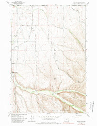
1964 Map of Bowlus Hill
USGS Topo · Published 1965About this map
The confluence of the North Fork and South Fork Walla Walla River defines this 1964 survey of the Oregon-Washington borderlands. This rugged agricultural and timber landscape transitions from the flat valley floor near Milton-Freewater to the high ridges of Blalock Mountain and Lincton Mountain. The small settlement of Spofford sits near the State Line, marked by its prominent Grain Elevator along the railroad, serving the wheat-growing country of the Walla Walla Valley. Local heritage is deeply rooted in the land, as evidenced by the Bowlus Cemetery and the isolated Forks Sch located where the river forks meet. In addition to the river systems, irrigation and utility infrastructure are visible through the network of the Powerline and Pipeline that traverse the terrain near Bowlus Hill.
Find a feature on this map
31 named features on this map. Tap any name to fly to it.
Don’t see what you’re looking for? This feature index may not catch every label — zoom into the map to look around manually.
Map Details
Editions of this 1964 Bowlus Hill Map
2 editions found
Other maps of this area

1919 · Walla Walla
USGS Topo · 1:125,000

1921 · Walla Walla
USGS Topo · 1:125,000

1953 · Pendleton
USGS Topo · 1:250,000

1953 · Walla Walla
USGS Topo · 1:250,000

1956 · Pendleton
USGS Topo · 1:250,000

1958 · Walla Walla
USGS Topo · 1:250,000

1963 · Blalock Mountain
USGS Topo · 1:24,000

1963 · Peterson Ridge
USGS Topo · 1:24,000

1964 · Milton-Freewater
USGS Topo · 1:24,000

1964 · Athena
USGS Topo · 1:24,000