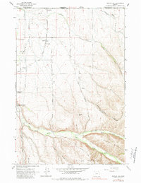
1964 Map of Bowlus Hill
USGS Topo · Published 1984About this map
Walla Walla Valley agriculture and highland terrain meet along the Oregon-Washington border in this mid-century survey. The agricultural settlement of Spofford sits along the Union Pacific tracks, marked by its grain elevator, while the eastern edge of Milton-Freewater establishes the regional hub. The landscape transitions sharply from the level valley floor into the dissected uplands of Blalock Mountain and Lincton Mountain, where the North Fork and South Fork of the Walla Walla River converge.
Find a feature on this map
31 named features on this map. Tap any name to fly to it.
Don’t see what you’re looking for? This feature index may not catch every label — zoom into the map to look around manually.
Map Details
Editions of this 1964 Bowlus Hill Map
2 editions found

Other maps of this area

1919 · Walla Walla
USGS Topo · 1:125,000

1921 · Walla Walla
USGS Topo · 1:125,000

1953 · Pendleton
USGS Topo · 1:250,000

1953 · Walla Walla
USGS Topo · 1:250,000

1956 · Pendleton
USGS Topo · 1:250,000

1958 · Walla Walla
USGS Topo · 1:250,000

1963 · Blalock Mountain
USGS Topo · 1:24,000

1963 · Peterson Ridge
USGS Topo · 1:24,000

1964 · Milton-Freewater
USGS Topo · 1:24,000

1964 · Athena
USGS Topo · 1:24,000