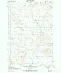
1968 Map of Bowman SW
USGS Topo · Published 1990About this map
Cold Turkey Creek and Spring Creek carve through the high plains of the Bowman and Gem townships in this late 1960s study. The landscape is defined by the ephemeral water drainage patterns typical of the North Dakota badlands border, where small reservoirs like Unks Dam managed local runoff. The area shows evidence of light industrial activity, specifically centered on material extraction for local road building and surfacing. Small-scale operations such as a Scoria Pit and multiple Gravel Pit locations are noted alongside the headwaters of Alkali Creek. The map provides a detailed view of the section lines and field boundaries in Ladd and Amor, reflecting the organized agricultural layout of the region during this era.
Find a feature on this map
16 named features on this map. Tap any name to fly to it.
Don’t see what you’re looking for? This feature index may not catch every label — zoom into the map to look around manually.
Map Details
Editions of this 1968 Bowman SW Map
2 editions found
Other maps of this area

1935 · Reva
USGS Topo · 1:125,000

1935 · Buffalo
USGS Topo · 1:125,000

1953 · Dickinson
USGS Topo · 1:250,000

1954 · Lemmon
USGS Topo · 1:250,000

1957 · Dickinson
USGS Topo · 1:250,000

1957 · Lemmon
USGS Topo · 1:250,000

1968 · Bowman SW
USGS Topo · 1:24,000

1968 · Bowman
USGS Topo · 1:24,000

1968 · Eagles Nest Butte
USGS Topo · 1:24,000

1968 · Tepee Buttes
USGS Topo · 1:24,000