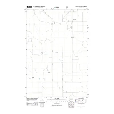
2011 Map of Boyce Creek East
USGS Topo · Published 2011About this map
The community of Mound and its surrounding ranchlands characterize this portion of Slope County in the early 21st century. The landscape is defined by the drainages of Boyce Creek and Spring Creek, which wind through a network of rural section lines and access roads. The map documents several named family holdings, including Wolfgrum Ranch in the north and the Janikowski Ranch further south, illustrating the enduring agricultural patterns of the North Dakota prairie. North-south transit is anchored by Rhame Rd, which connects these remote homesteads. The distribution of sites like the G and D Heinrich Ranch and both the G Strom Ranch and V Strom Ranch provides a clear record of local land tenure and the sparse, purposeful settlement pattern required for ranching in this environment.
Find a feature on this map
28 named features on this map. Tap any name to fly to it.
Don’t see what you’re looking for? This feature index may not catch every label — zoom into the map to look around manually.
Map Details
Editions of this 2011 Boyce Creek East Map
This is the sole edition of this map. No revisions or reprints were ever made.
Other maps of this area

1953 · Dickinson
USGS Topo · 1:250,000

1957 · Dickinson
USGS Topo · 1:250,000

1979 · Deep Creek North
USGS Topo · 1:24,000

1979 · Three V Crossing
USGS Topo · 1:24,000

1979 · Ives
USGS Topo · 1:24,000

1980 · Spring Creek
USGS Topo · 1:24,000

1980 · Boyce Creek West
USGS Topo · 1:24,000

1980 · Belfield
USGS Topo · 1:100,000

1981 · Bowman
USGS Topo · 1:100,000
1997 · Deep Creek North
USGS Topo · 1:24,000