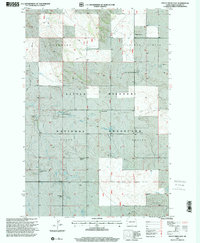
1997 Map of Boyce Creek East
USGS Topo · Published 2001About this map
Little Missouri National Grassland dominates this corner of Slope County, showing a landscape defined by isolated ranching operations and vast open country. Private holdings like the Wolfgram Ranch and Janikowski Ranch are scattered across the terrain, connected by primitive roads and four-wheel-drive trails. The presence of the Mound Ch and a nearby Cem indicates a established rural community focal point amid the township's sections.
Find a feature on this map
22 named features on this map. Tap any name to fly to it.
Don’t see what you’re looking for? This feature index may not catch every label — zoom into the map to look around manually.
Map Details
Editions of this 1997 Boyce Creek East Map
This is the sole edition of this map. No revisions or reprints were ever made.
Other maps of this area

1953 · Dickinson
USGS Topo · 1:250,000

1957 · Dickinson
USGS Topo · 1:250,000

1979 · Deep Creek North
USGS Topo · 1:24,000

1979 · Three V Crossing
USGS Topo · 1:24,000

1979 · Ives
USGS Topo · 1:24,000

1980 · Spring Creek
USGS Topo · 1:24,000

1980 · Boyce Creek West
USGS Topo · 1:24,000

1980 · Belfield
USGS Topo · 1:100,000

1981 · Bowman
USGS Topo · 1:100,000
1997 · Deep Creek North
USGS Topo · 1:24,000