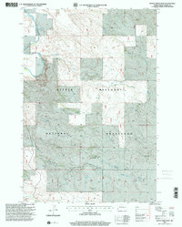
1997 Map of Boyce Creek West
USGS Topo · Published 2001About this map
The Little Missouri National Grassland dominates this landscape in Slope County, where the high plains of western North Dakota meet the carved drainage systems of the Little Missouri River. This late-twentieth-century survey illustrates a sparse ranching economy defined by isolated outposts such as Oldis Ranch and Rue Ranch. The terrain is marked by prominent topographic features like Sunshine Mound, while water access is critical, as evidenced by several Flowing Wells and the courses of Boyce Creek, Cash Creek, and Indian Creek. The presence of a Gravel Pit indicates local resource extraction amidst the grazing lands. This map captures the region's character as it transitioned into the modern era, maintaining its traditional agricultural and public land usage patterns.
Find a feature on this map
15 named features on this map. Tap any name to fly to it.
Don’t see what you’re looking for? This feature index may not catch every label — zoom into the map to look around manually.
Map Details
Editions of this 1997 Boyce Creek West Map
This is the sole edition of this map. No revisions or reprints were ever made.
Other maps of this area

1953 · Dickinson
USGS Topo · 1:250,000

1957 · Dickinson
USGS Topo · 1:250,000

1979 · Three V Crossing
USGS Topo · 1:24,000

1979 · Ives
USGS Topo · 1:24,000

1980 · Spring Creek
USGS Topo · 1:24,000

1980 · Pretty Butte
USGS Topo · 1:24,000

1980 · Marmarth
USGS Topo · 1:24,000

1980 · Boyce Creek West
USGS Topo · 1:24,000

1980 · Belfield
USGS Topo · 1:100,000

1981 · Bowman
USGS Topo · 1:100,000