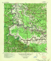
1941 Map of Boyce
USGS Topo · Published 1949About this map
The Red River winds through the heart of Rapides Parish, defining a landscape of fertile alluvial bottoms and expansive timberlands. During the early 1940s, this region was characterized by a distinct plantation economy and early aviation development, as evidenced by the Alexandria Municipal Airport, then noted as being under construction. Significant agricultural estates like Santiago Plantation, Bynum Plantation, and Village Plantation border the river, while the higher ground is dominated by the Kisatchie National Forest Catahoula Division. This survey provides a rare look at the institutional and rural social structures of the era, from the sprawling grounds of the Central La Hospital For Insane to numerous localized centers of faith and education such as St Matthias Ch & Sch and Tabernacle Ch & Sch. Railroad corridors, including the Texas and Pacific RR, connect river towns like Boyce and Zimmerman to the broader regional markets.
Find a feature on this map
105 named features on this map. Tap any name to fly to it.
Don’t see what you’re looking for? This feature index may not catch every label — zoom into the map to look around manually.
Map Details
Editions of this 1941 Boyce Map
2 editions found

Other maps of this area

1932 · Boyce NE
USGS Topo · 1:31,680

1932 · Boyce SW
USGS Topo · 1:31,680

1932 · Colfax SW
USGS Topo · 1:31,680

1932 · Colfax SE
USGS Topo · 1:31,680

1935 · Lecompte
USGS Topo · 1:62,500

1936 · Colfax
USGS Topo · 1:62,500

1936 · Pollock
USGS Topo · 1:62,500

1937 · Chopin NE
USGS Topo · 1:31,680

1937 · Aloha
USGS Topo · 1:31,680

1937 · Montgomery
USGS Topo · 1:62,500