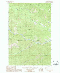
1988 Map of Boyd Mountain
USGS Topo · Published 1988About this map
Lolo National Forest encompasses this rugged stretch of Mineral County, where the steep topography of Boyd Mountain overlooks a landscape shaped by historical transport and extraction. The St Regis River serves as the primary drainage, joined by numerous tributaries including Twentuemile Creek and Twomile Creek. Industrial history is etched into the terrain via the Old RR Grade, which follows the river valley, marking the path of former rail operations that once served this timber and mineral-rich region. Local mining activity is evidenced by the Ben Pitt Mines located near Mullan Gulch. The map also details the convergences of the North Fork and South Fork, illustrating the complex drainage network that defines this part of the Bitterroot Range during the late twentieth century.
Find a feature on this map
15 named features on this map. Tap any name to fly to it.
Don’t see what you’re looking for? This feature index may not catch every label — zoom into the map to look around manually.
Map Details
Editions of this 1988 Boyd Mountain Map
This is the sole edition of this map. No revisions or reprints were ever made.
Other maps of this area

1918 · St Regis
USGS Topo · 1:125,000

1919 · St. Regis
USGS Topo · 1:125,000

1956 · St Regis
USGS Topo · 1:62,500

1956 · Wallace
USGS Topo · 1:250,000

1957 · Illinois Peak
USGS Topo · 1:62,500

1957 · Haugan
USGS Topo · 1:62,500

1957 · Simmons Peak
USGS Topo · 1:62,500

1960 · Wallace
USGS Topo · 1:250,000
1988 · St Regis
USGS Topo · 1:24,000
1988 · Torino Peak
USGS Topo · 1:24,000