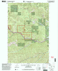
1999 Map of Boyd Mountain
USGS Topo · Published 2003About this map
The St Regis River flows through the heart of the Lolo National Forest, carving a narrow valley floor that has historically served as a vital corridor for travel and communication. This late-twentieth-century landscape is defined by the high peaks of Boyd Mountain and Camel Hump, where a network of tributary drainages like Wolf Creek and Keith Creek feeds the river system. The presence of Mullan Gulch hints at the enduring legacy of early transportation routes through these northern mountain passes. Steep timbered ridges and deep-cut gulches, including Wilson Gulch and Twentymile Creek, dominate the terrain, reflecting the conservation-focused management of the Forest Service during the 1990s. The map illustrates a landscape where human utility is concentrated along the riverbanks, while the vast majority of the quadrangle remains a wilderness of named creeks and high summits.
Find a feature on this map
16 named features on this map. Tap any name to fly to it.
Don’t see what you’re looking for? This feature index may not catch every label — zoom into the map to look around manually.
Map Details
Editions of this 1999 Boyd Mountain Map
This is the sole edition of this map. No revisions or reprints were ever made.
Other maps of this area

1918 · St Regis
USGS Topo · 1:125,000

1919 · St. Regis
USGS Topo · 1:125,000

1956 · St Regis
USGS Topo · 1:62,500

1956 · Wallace
USGS Topo · 1:250,000

1957 · Illinois Peak
USGS Topo · 1:62,500

1957 · Haugan
USGS Topo · 1:62,500

1957 · Simmons Peak
USGS Topo · 1:62,500

1960 · Wallace
USGS Topo · 1:250,000
1988 · St Regis
USGS Topo · 1:24,000
1988 · Torino Peak
USGS Topo · 1:24,000