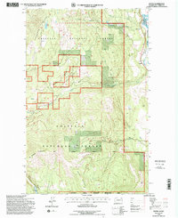
1992 Map of Boyds
USGS Topo · Published 1996About this map
Boyds serves as the primary settlement hub in this 1990s-era map of eastern Ferry County, situated where the Burlington Northern line tracks the sweeping curves of the Kettle River. The landscape is dominated by the dense, managed woodlands of the Colville National Forest, where topography rises sharply from the river valley into massive features like Hoodoo Mountain and Bisbee Mountain.
Find a feature on this map
20 named features on this map. Tap any name to fly to it.
Don’t see what you’re looking for? This feature index may not catch every label — zoom into the map to look around manually.
Map Details
Editions of this 1992 Boyds Map
This is the sole edition of this map. No revisions or reprints were ever made.
Other maps of this area

1936 · Marcus
USGS Topo · 1:96,000

1942 · Marcus
USGS Topo · 1:125,000

1948 · Sherman Peak
USGS Topo · 1:62,500

1948 · Kettle Falls
USGS Topo · 1:62,500

1948 · Orient
USGS Topo · 1:62,500

1948 · Togo Mountain
USGS Topo · 1:62,500

1951 · Togo Mountain
USGS Topo · 1:62,500

1951 · Sherman Peak
USGS Topo · 1:62,500

1951 · Orient
USGS Topo · 1:62,500

1951 · Kettle Falls
USGS Topo · 1:62,500