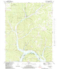
1983 Map of Boylers Mill
USGS Topo · Published 1983About this map
Boylers Mill and its namesake Boylers Mill Spring anchor this 1983 topographic study of the rugged borderlands between Benton and Morgan counties. The landscape is defined by the winding course of Big Buffalo Creek as it flows south toward the northern reaches of the Lake of the Ozarks. This era of the reservoir is captured through underwater contours derived from earlier Union Electric Company charts, revealing the submerged channel of the Osage River beneath the cove.
Find a feature on this map
56 named features on this map. Tap any name to fly to it.
Don’t see what you’re looking for? This feature index may not catch every label — zoom into the map to look around manually.
Map Details
Editions of this 1983 Boylers Mill Map
This is the sole edition of this map. No revisions or reprints were ever made.
Other maps of this area

1887 · Warsaw
USGS Topo · 1:125,000

1888 · Versailles
USGS Topo · 1:125,000

1893 · Versailles
USGS Topo · 1:125,000

1894 · Warsaw
USGS Topo · 1:125,000

1904 · Gravois Mills
USGS Topo · 1:62,500

1934 · Irontown Ferry
USGS Topo · 1:24,000

1935 · Proctor Creek
USGS Topo · 1:24,000

1935 · Edwards
USGS Topo · 1:24,000

1935 · Boylers Mill
USGS Topo · 1:24,000

1935 · Knobby Creek
USGS Topo · 1:24,000