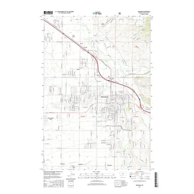
2017 Map of Bozeman
USGS Topo · Published 2017About this map
Bozeman serves as the central hub of this Gallatin County survey, showing the city's modern footprint including the expansive Montana State Univ campus and the historic Sunset Hills Cem near the downtown core. The surrounding landscape is defined by an intricate network of irrigation and water management, featuring the W Gallatin Canal, Middle Cr Ditch, and Beck Border Ditch. These waterways support the outlying agricultural communities of Story, Bisel, Catron, and Patterson. To the northeast, the terrain rises toward Sypes Canyon and Big Gulch Dr, while the East Gallatin River and Bridger Cr wind through the valley floor. The map captures the intersection of traditional landmarks like the Brondel Catholic Cem with modern transportation infrastructure like Haggerty Airport and the Frontage Rd.
Find a feature on this map
54 named features on this map. Tap any name to fly to it.
Don’t see what you’re looking for? This feature index may not catch every label — zoom into the map to look around manually.
Map Details
Editions of this 2017 Bozeman Map
This is the sole edition of this map. No revisions or reprints were ever made.
Other maps of this area

1888 · Three Forks
USGS Topo · 1:250,000

1891 · Livingston
USGS Topo · 1:250,000

1893 · Livingston
USGS Topo · 1:250,000

1894 · Three Forks
USGS Topo · 1:250,000

1895 · Three Forks
USGS Topo · 1:250,000

1947 · Bozeman
USGS Topo · 1:250,000

1948 · Bozeman
USGS Topo · 1:250,000

1950 · Belgrade
USGS Topo · 1:62,500

1951 · Bozeman Pass
USGS Topo · 1:62,500

1951 · Sedan
USGS Topo · 1:62,500