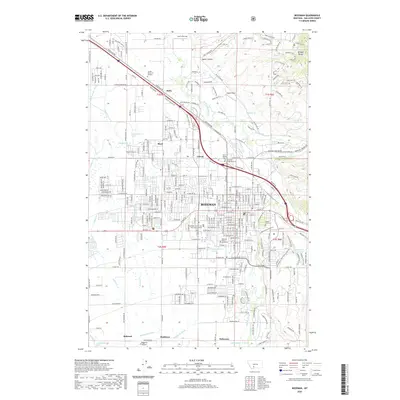
2020 Map of Bozeman
USGS Topo · Published 2020About this map
Bozeman serves as the focal point of this Gallatin County survey, which documents the city's modern footprint and educational core at Montana State University. The landscape transition is evident where the urban grid, centered around W Main St and E Main St, meets the rising terrain of the Bridger Range to the northeast. Several cemeteries, including Sunset Hills Cem and Sunset Memorial Gardens, anchor the historical memory of the community. Beyond the city center, smaller named settlements such as Catron, Bisel, and Story indicate the continued development along the East Gallatin River corridor. Water management for the valley is well-documented through features like the W Gallatin Canal and Middle Cr Ditch, illustrating the area's ongoing reliance on irrigation infrastructure. The map also identifies local aviation hubs including Edsall Field and Haggerty Airport.
Find a feature on this map
91 named features on this map. Tap any name to fly to it.
Don’t see what you’re looking for? This feature index may not catch every label — zoom into the map to look around manually.
Map Details
Editions of this 2020 Bozeman Map
This is the sole edition of this map. No revisions or reprints were ever made.
Other maps of this area

1888 · Three Forks
USGS Topo · 1:250,000

1891 · Livingston
USGS Topo · 1:250,000

1893 · Livingston
USGS Topo · 1:250,000

1894 · Three Forks
USGS Topo · 1:250,000

1895 · Three Forks
USGS Topo · 1:250,000

1947 · Bozeman
USGS Topo · 1:250,000

1948 · Bozeman
USGS Topo · 1:250,000

1950 · Belgrade
USGS Topo · 1:62,500

1951 · Bozeman Pass
USGS Topo · 1:62,500

1951 · Sedan
USGS Topo · 1:62,500