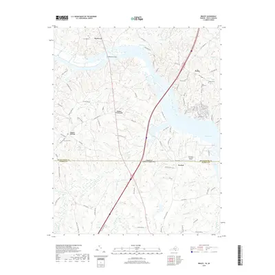
2019 Map of Bracey
USGS Topo · Published 2019About this map
Lake Gaston dominates the eastern edge of this landscape along the border of Virginia and North Carolina, where the interstate highway corridor bisects the rural terrain of Mecklenburg and Warren Counties. The settlement of Bracey sits north of the water, characterized by its proximity to the lake and several local burial grounds including Kingswood Cem and Saint Marks Cem. To the west, the community of Palmer Springs remains a key inland point of interest, served by local routes like The Holler Rd and home to Grace Cem. The geography is defined by a dense network of creek systems such as Smith Cr, Flat Creek, and Reedy Br, which flow through the undulating land toward the larger reservoir. Further south, the map identifies the Martindale Executive Airpark near Paschall, highlighting the modern aviation infrastructure that serves this cross-border region alongside traditional landmarks like Goodes Ferry Bridge.
Find a feature on this map
87 named features on this map. Tap any name to fly to it.
Don’t see what you’re looking for? This feature index may not catch every label — zoom into the map to look around manually.
Map Details
Editions of this 2019 Bracey Map
This is the sole edition of this map. No revisions or reprints were ever made.
Other maps of this area

1953 · Greensboro
USGS Topo · 1:250,000

1954 · Greensboro
USGS Topo · 1:250,000

1955 · Boydton
USGS Topo · 1:62,500

1962 · Greensboro
USGS Topo · 1:250,000

1966 · Greensboro
USGS Topo · 1:250,000

1968 · South Hill SE
USGS Topo · 1:24,000

1968 · Bracey
USGS Topo · 1:24,000

1968 · John H Kerr Dam
USGS Topo · 1:24,000
1968 · La Crosse
USGS Topo · 1:24,000
1968 · Baskerville
USGS Topo · 1:24,000