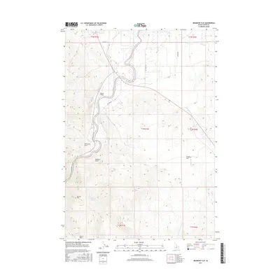
2017 Map of Bradbury Flat
USGS Topo · Published 2017About this map
The Salmon River defines the western edge of this Custer County landscape, winding through Round Valley before entering steeper terrain. This 2017 study illustrates the sparse road network and high-elevation parklands characteristic of this part of Idaho. Rural access is provided by family-named routes such as Hammond Ln, Westergard, and Hot Springs Rd, reflecting the ranching and agricultural legacies of the region. The map highlights numerous drainage and topographic features including Mud Spring Gulch, Bradbury Gulch, and the high plateau of Bradbury Flat. To the south, the terrain rises toward Germer Park and Germer Basin, while water sources like Bishop Spring and various creeks, including Warm Spring Cr and Lone Pine Cr, drain the surrounding slopes. The layout of the Public Land Survey System sections underscores the organized yet remote nature of the territory.
Find a feature on this map
22 named features on this map. Tap any name to fly to it.
Don’t see what you’re looking for? This feature index may not catch every label — zoom into the map to look around manually.
Map Details
Editions of this 2017 Bradbury Flat Map
This is the sole edition of this map. No revisions or reprints were ever made.
Other maps of this area

1929 · Bayhorse
USGS Topo · 1:125,000

1956 · Challis
USGS Topo · 1:62,500

1956 · Twin Peaks
USGS Topo · 1:62,500

1957 · Challis
USGS Topo · 1:250,000

1960 · Challis
USGS Topo · 1:250,000

1963 · Challis
USGS Topo · 1:250,000

1963 · Bald Mountain
USGS Topo · 1:24,000

1963 · Bayhorse
USGS Topo · 1:24,000
1963 · Little Antelope Flat
USGS Topo · 1:24,000

1963 · Clayton
USGS Topo · 1:62,500