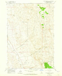
1963 Map of Little Antelope Flat
USGS Topo · Published 1965About this map
Pahsimeroi Mountains and the Lost River Range converge in this high-altitude Custer County landscape, where the Challis National Forest boundary cuts through a complex system of basins and springs. The map documents a high-desert environment defined by seasonal water sources and livestock or hunting access routes, such as the Hole-in-Rock Trail and numerous unnamed jeep trails. Little Antelope Flat occupies the lower southern reaches of the quadrangle, serving as a primary drainage point for the surrounding highlands, including Warm Spring Creek and Hole-in-Rock Creek. Notable landmarks like Table Mtn and Red Hill provided essential visual navigation for those traversing the remote cattle and pack routes of the early 1960s. The naming of Spud Basin and Gooseberry Spring reflects a local nomenclature tied to the practical resources and geography of central Idaho.
Find a feature on this map
25 named features on this map. Tap any name to fly to it.
Don’t see what you’re looking for? This feature index may not catch every label — zoom into the map to look around manually.
Map Details
Editions of this 1963 Little Antelope Flat Map
2 editions found
Other maps of this area

1929 · Bayhorse
USGS Topo · 1:125,000

1935 · Borah Peak
USGS Topo · 1:125,000

1938 · Borah Peak
USGS Topo · 1:125,000

1955 · Dubois
USGS Topo · 1:250,000

1956 · Doublespring
USGS Topo · 1:62,500

1956 · May
USGS Topo · 1:62,500

1956 · Challis
USGS Topo · 1:62,500

1957 · Challis
USGS Topo · 1:250,000

1958 · Dubois
USGS Topo · 1:250,000

1960 · Challis
USGS Topo · 1:250,000