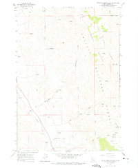
1963 Map of Little Antelope Flat
USGS Topo · Published 1975About this map
Little Antelope Flat serves as the central focal point of this high-altitude landscape in central Idaho, where the high-country terrain of the Challis National Forest is defined by a network of seasonal water sources and rugged travel routes. The 1963 field check documents a remote wilderness managed for its natural resources, notably featuring the Hole-in-Rock Trail and numerous jeep trails that navigate the steep slopes between Red Hill and Table Mtn. This period of forest management is characterized by named water features essential for range and wildlife, including Gooseberry Spring, Opal Spring, and the perennial flows of Warm Spring Creek. The map illustrates the convergence of the Challis Mountains and the Pahsimeroi River Range, providing a detailed record of the drainage patterns through Devil Canyon and into the broad basins of Spud Basin and Crane Basin.
Find a feature on this map
22 named features on this map. Tap any name to fly to it.
Don’t see what you’re looking for? This feature index may not catch every label — zoom into the map to look around manually.
Map Details
Editions of this 1963 Little Antelope Flat Map
2 editions found
Other maps of this area

1929 · Bayhorse
USGS Topo · 1:125,000

1935 · Borah Peak
USGS Topo · 1:125,000

1938 · Borah Peak
USGS Topo · 1:125,000

1955 · Dubois
USGS Topo · 1:250,000

1956 · Doublespring
USGS Topo · 1:62,500

1956 · May
USGS Topo · 1:62,500

1956 · Challis
USGS Topo · 1:62,500

1957 · Challis
USGS Topo · 1:250,000

1958 · Dubois
USGS Topo · 1:250,000

1960 · Challis
USGS Topo · 1:250,000