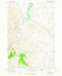
1963 Map of Bradbury Flat
USGS Topo · Published 1965About this map
Salmon River waters carve through this Idaho landscape, defining the western boundary of the wide Round Valley and the adjacent Bradbury Flat. The 1963 field check reveals a network of waterways and springs, such as Hannah Slough and Bishop Spring, that supported the grazing and ranching operations indicated by the numerous fence lines across the valley floor. The terrain transitions from the low-lying flats to the higher elevations of Germer Peak and Germer Basin in the southwest corner. Transportation in this era was dominated by a sparse network of unimproved routes and a Jeep Trail, illustrating the remote nature of Custer County before modern infrastructure was fully established. Local land use is further marked by features like a Gravel Pit and a remote Well, providing a record of mid-century rural resource management.
Find a feature on this map
18 named features on this map. Tap any name to fly to it.
Don’t see what you’re looking for? This feature index may not catch every label — zoom into the map to look around manually.
Map Details
Editions of this 1963 Bradbury Flat Map
This is the sole edition of this map. No revisions or reprints were ever made.
Other maps of this area

1929 · Bayhorse
USGS Topo · 1:125,000

1956 · Challis
USGS Topo · 1:62,500

1956 · Twin Peaks
USGS Topo · 1:62,500

1957 · Challis
USGS Topo · 1:250,000

1960 · Challis
USGS Topo · 1:250,000

1963 · Challis
USGS Topo · 1:250,000

1963 · Bald Mountain
USGS Topo · 1:24,000

1963 · Bayhorse
USGS Topo · 1:24,000
1963 · Little Antelope Flat
USGS Topo · 1:24,000

1963 · Clayton
USGS Topo · 1:62,500