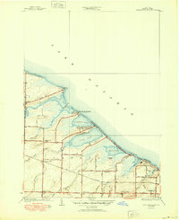
1934 Map of Braddock Heights
USGS Topo · Published 1950About this map
The town of Greece lines the southern shore of Lake Ontario in this early 1930s topography, showing a coastline defined by a series of large ponds and developing seasonal beach communities. Braddock Bay serves as the central anchor for these wetlands, flanked by Cranberry Pond, Long Pond, Buck Pond, and Round Pond. The map captures the transition from a traditional agricultural interior, centered around the Greece Sta rail stop and the settlement of North Greece, toward a recreational waterfront. Narrow strips of land between the ponds and the lake are partitioned into dense colonies like Grand View Beach and Crescent Beach. Local infrastructure is marked by several district schoolhouses, including Frisbee Hill Sch and School No 2, while the interior drainage is managed by numerous named waterways such as Salmon Creek and Larkin Creek.
Find a feature on this map
51 named features on this map. Tap any name to fly to it.
Don’t see what you’re looking for? This feature index may not catch every label — zoom into the map to look around manually.
Map Details
Editions of this 1934 Braddock Heights Map
Other maps of this area

1895 · Rochester
USGS Topo · 1:62,500

1895 · Ontario Beach
USGS Topo · 1:62,500

1898 · Rochester
USGS Topo · 1:62,500

1899 · Hamlin
USGS Topo · 1:62,500

1899 · Ontario Beach
USGS Topo · 1:62,500

1899 · Brockport
USGS Topo · 1:62,500

1912 · Rochester
USGS Topo · 1:62,500

1912 · Ontario Beach
USGS Topo · 1:62,500

1920 · Rochester
USGS Topo · 1:62,500

1931 · Rochester West
USGS Topo · 1:24,000