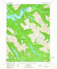
1955 Map of Bradfield Canal A-5
USGS Topo · Published 1964About this map
The Bradfield Canal and its surrounding glacial-fed waterways define this coastal portion of the Tongass National Forest. In the mid-1950s, the landscape was largely characterized by its complex hydrography, including the Harding River and the braided outflows of the White River. Evidence of human presence is sparse but distinct, marked by a Gaging Sta on the upper canal and unidentified Ruins near Bell Arm. The interior terrain is dominated by the Kapho Mountains and prominent peaks like Mount Tyee, which towers over the high-elevation Tyee Lake. Significant freshwater bodies such as Reflection Lake and Eagle Lake drain through the Eagle River system into the saltwater of Eagle Bay. This survey captures the wilderness in a transitional period, utilizing aerial photography from 1948 to map the intricate shorelines and tidal flats before further modern development reached this corner of the Alaska panhandle.
Find a feature on this map
25 named features on this map. Tap any name to fly to it.
Don’t see what you’re looking for? This feature index may not catch every label — zoom into the map to look around manually.
Map Details
Editions of this 1955 Bradfield Canal A-5 Map
2 editions found

Other maps of this area

1951 · Bradfield Canal
USGS Topo · 1:250,000

1952 · Ketchikan
USGS Topo · 1:250,000

1952 · Ketchikan D-5
USGS Topo · 1:63,360

1952 · Ketchikan D-6
USGS Topo · 1:63,360

1953 · Ketchikan D-5
USGS Topo · 1:63,360

1953 · Ketchikan D-6
USGS Topo · 1:63,360

1954 · Bradfield Canal
USGS Topo · 1:250,000

1955 · Bradfield canal A-6
USGS Topo · 1:63,360

1955 · Bradfield canal A-4
USGS Topo · 1:63,360

1955 · Bradfield canal B-5
USGS Topo · 1:63,360