
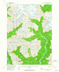
1955 Map of Bradfield canal B-5
USGS Topo · Published 1959About this map
Kapho Mountains dominate the southern reach of this mid-century survey, a landscape defined by glacial activity and high-altitude drainage systems. Located within the Tongass National Forest, the area is marked by the branching networks of the Harding River to the west and the North Bradfield River to the east. A lone Cabin situated along the North Bradfield River serves as the only evidence of human structures in this wilderness. The terrain is characterized by steep contour gradients rising from the White River valley toward unnamed peaks and snowfields. Significant water features like Full Lake are nestled in the high basins, illustrating the complex hydrology of the region as it was documented by the U.S. Geological Survey using aerial photography from the late 1940s.
Find a feature on this map
6 named features on this map. Tap any name to fly to it.
Don’t see what you’re looking for? This feature index may not catch every label — zoom into the map to look around manually.
Map Details
Editions of this 1955 Bradfield canal B-5 Map
2 editions found
Other maps of this area

1951 · Bradfield Canal
USGS Topo · 1:250,000

1954 · Bradfield Canal
USGS Topo · 1:250,000

1955 · Bradfield canal A-6
USGS Topo · 1:63,360

1955 · Bradfield canal A-4
USGS Topo · 1:63,360

1955 · Bradfield canal B-4
USGS Topo · 1:63,360

1955 · Bradfield canal C-6
USGS Topo · 1:63,360

1955 · Bradfield Canal A-5
USGS Topo · 1:63,360

1955 · Bradfield canal B-6
USGS Topo · 1:63,360
1955 · Bradfield Canal C-5
USGS Topo · 1:63,360

1955 · Bradfield Canal
USGS Topo · 1:250,000