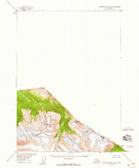
1955 Map of Bradfield Canal C-5
USGS Topo · Published 1959About this map
Katete River flows through the heart of this mid-century survey, cutting through the glacially carved landscape of the Tongass National Forest. The map documents a critical segment of the international boundary where British Columbia and Alaska meet, following the high ridge lines between Mt Whipple and Mt Fawcett. This cartographic record, based on 1948 aerial photography and 1955 field annotation, captures the transition from United States territory into Canada. The topography is defined by sharp elevation changes and high mountain peaks, illustrating the isolation of the boundary region before the development of modern infrastructure in the area.
Find a feature on this map
6 named features on this map. Tap any name to fly to it.
Don’t see what you’re looking for? This feature index may not catch every label — zoom into the map to look around manually.
Map Details
Editions of this 1955 Bradfield Canal C-5 Map
2 editions found
Other maps of this area

1951 · Bradfield Canal
USGS Topo · 1:250,000

1954 · Bradfield Canal
USGS Topo · 1:250,000

1955 · Bradfield canal B-5
USGS Topo · 1:63,360

1955 · Bradfield canal B-4
USGS Topo · 1:63,360

1955 · Bradfield canal D-6
USGS Topo · 1:63,360

1955 · Bradfield canal C-6
USGS Topo · 1:63,360

1955 · Bradfield canal B-6
USGS Topo · 1:63,360

1955 · Bradfield Canal
USGS Topo · 1:250,000
2000 · Bradfield Canal B-6
USGS Topo · 1:63,360
2017 · Bradfield Canal B-5 NE
USGS Topo · 1:25,000