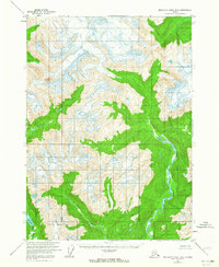
1955 Map of Bradfield canal B-5
USGS Topo · Published 1964About this map
The Kapho Mountains dominate this mid-century topographic survey, where the drainages of the Harding River and the North Fork Bradfield River carve through high-elevation terrain. This remote wilderness, entirely contained within the Tongass National Forest, represents a landscape of ice and water as it was recorded during aerial photography in 1948 and field-annotated in 1955. The map documents the intricate hydrology of the region, including the White River and Fall Lake. Lacking roads or trails at the time of survey, the sheet highlights the natural barriers and river corridors that dictated access for early resource explorers and surveyors in this part of Southeast Alaska.
Find a feature on this map
6 named features on this map. Tap any name to fly to it.
Don’t see what you’re looking for? This feature index may not catch every label — zoom into the map to look around manually.
Map Details
Editions of this 1955 Bradfield canal B-5 Map
2 editions found
Other maps of this area

1951 · Bradfield Canal
USGS Topo · 1:250,000

1954 · Bradfield Canal
USGS Topo · 1:250,000

1955 · Bradfield canal A-6
USGS Topo · 1:63,360

1955 · Bradfield canal A-4
USGS Topo · 1:63,360

1955 · Bradfield canal B-5
USGS Topo · 1:63,360

1955 · Bradfield canal B-4
USGS Topo · 1:63,360

1955 · Bradfield canal C-6
USGS Topo · 1:63,360

1955 · Bradfield Canal A-5
USGS Topo · 1:63,360

1955 · Bradfield canal B-6
USGS Topo · 1:63,360
1955 · Bradfield Canal C-5
USGS Topo · 1:63,360