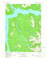
1955 Map of Bradfield canal A-6
USGS Topo · Published 1963About this map
Ernest Sound and Seward Passage dominate the western portion of this mid-century maritime survey, framing the complex coastline of the Tongass National Forest. The map reveals an intricate network of inland water bodies and drainage systems, most notably the connection between Anan Bay, Anan Lagoon, and the long, linear profile of Anan Lake. This area of Southeast Alaska is defined by its deep saltwater channels and high-elevation freshwater lakes, such as Boulder Lake and Lake Rowena. Evidence of human presence is sparse in this 1955 update, noted only by a lone Cabin near the mouth of Anan Creek. The coastal landscape is further characterized by significant landmasses like Wrangell Island and Blake Island situated at the mouth of the Bradfield Canal.
Find a feature on this map
24 named features on this map. Tap any name to fly to it.
Don’t see what you’re looking for? This feature index may not catch every label — zoom into the map to look around manually.
Map Details
Editions of this 1955 Bradfield canal A-6 Map

Other maps of this area

1948 · Petersburg A-1
USGS Topo · 1:63,360

1948 · Petersburg B-1
USGS Topo · 1:63,360

1949 · Craig D-1
USGS Topo · 1:63,360

1951 · Bradfield Canal
USGS Topo · 1:250,000

1951 · Craig D-1
USGS Topo · 1:63,360

1951 · Petersburg A-1
USGS Topo · 1:63,360

1952 · Petersburg
USGS Topo · 1:250,000

1952 · Ketchikan
USGS Topo · 1:250,000

1952 · Ketchikan D-5
USGS Topo · 1:63,360

1952 · Ketchikan D-6
USGS Topo · 1:63,360